Are you planning to buy or sell a property, or preparing a construction project? The French Urban Planning Geoportal has become an essential tool for checking the urban planning regulations that apply to your land parcel. This national platform allows you to consult all the urban planning documents for your municipality free of charge, including public utility easements, and anticipate constraints before launching your real estate project.
What Is the National Urban Planning Portal in France?
The Urban Planning Geoportal (GPU) is a national platform published by the French Ministry in charge of urban planning and managed in partnership with the IGN (National Geographic Institute). This tool allows you to consult all the urban planning documents for your municipality free of charge, along with public utility easements and geographic data at the scale of each parcel.
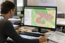
You can view the Local Urban Development Plan (PLU), municipal maps, territorial coherence schemes, and risk prevention plans. The platform offers several practical features: interactive map consultation, aerial photo overlays, and drawing tools to precisely locate your property. Access is completely free and open to everyone, with no registration required.
Where Can You Find the PLU and Urban Planning Documents on the French Geoportal?
To consult your municipality’s Local Urban Development Plan, go to the Urban Planning Geoportal and enter the address or municipality name in the search bar. The platform then displays the applicable urban planning documents: PLU, municipal map, SCoT, PSMV, or public utility easements. You can navigate through the various map layers to view the regulations applying to your parcel.
Accessing the Cadastral Map and Land Parcels
Once on the Geoportal, activate the cadastral layer to precisely identify the parcels concerned by your project. By clicking on a parcel, you can access its detailed information sheet including cadastral references (section, number) and the option to download or print this information. This step is essential for preparing a building permit application or verifying property boundaries before a purchase.
Consulting Zoning Plans and Site Layout Plans
The Geoportal allows you to overlay several map layers: cadastral base map, PLU zoning, prescriptions, and easements. This overlay helps you determine whether your parcel is located in an urban zone (U), development zone (AU), agricultural zone (A), or natural zone (N), and which regulations apply. To prepare a site layout plan, select the necessary layers and export the document that will serve as the basis for your project.
Type of Document | Usefulness for Your Real Estate Project |
|---|---|
PLU / PLUi | Understand buildability rules, zoning, and regulations applicable to your parcel |
Municipal Map | Identify buildable sectors in municipalities without a PLU |
SCoT | Understand development strategies at the intermunicipal level |
PSMV | Verify specific rules in protected sectors (historic centers) |
SUP | Consult public utility easements (networks, historic monuments, natural risks) |
What Are the Publication Obligations on the Geoportal in France?
Since January 1, 2023, any modification to a PLU or PLUi must be published on the Urban Planning Geoportal to become legally enforceable. This obligation, set out in Article L153-23 of the French Urban Planning Code, marks a turning point in the transparency of urban planning documents.
Municipal Maps, PLUs, and Territorial Coherence Schemes
Many documents are concerned: municipal maps, PLUs, PLUis, SCoTs, and PSMVs. To become enforceable, these documents must be transmitted to the prefect as part of legality control and published on the Geoportal. Digitalization must comply with the CNIG standard, which guarantees interoperability and data quality.
Preservation Plans and Public Utility Easements
Public utility easements (SUP) are also centralized on the platform. These administrative limitations on property rights include risk prevention plans, natural or cultural heritage protection zones, and right-of-way easements. This centralization facilitates access to information for real estate project developers.
Checklist of Regulatory Publication Obligations
- Digitization compliant with the CNIG standard
- Transmission to the prefect as part of legality control
- Publication on the Urban Planning Geoportal
- Acquisition of enforceable legal status after publication
How to Use the Geoportal for a Site Location Plan?
Prepare Your Real Estate Project Using This Public Service
The Urban Planning Geoportal allows you to easily generate a site location plan, a mandatory document for any building permit or prior declaration application. From the platform, search for your parcel, select the cadastral layer, and export the map as a PDF. This plan locates the land within the municipality and facilitates the processing of your application.
For buyers, consulting the Geoportal before purchasing allows you to verify the applicable regulations: maximum height, building footprint, public utility easements, or constraints related to risk prevention. This information helps you anticipate construction possibilities. For sellers, providing this information in advance reassures buyers and enhances your property’s value.
Contacting Your Municipality’s Urban Planning Department
If your project has specific features (parcel division, risk zones, complex easements), complement your Geoportal consultation by contacting your town hall’s urban planning department. Departmental territorial directorates can also assist local authorities and answer your technical questions.
To receive support for your real estate project, from regulation analysis to signing the deed of sale, contact an Optimhome advisor. Our local experts guide you through every step to secure your purchase or sale.
Frequently Asked Questions
Is Lidar Available on the Geoportal?
Lidar is not accessible through the Urban Planning Geoportal, but you can consult it on the IGN Geoportal (geoportail.gouv.fr). These 3D mapping data are particularly useful for analyzing the relief and topography of land before a construction project.
How Can You Access the Savoie Geoportal?
The Savoie Geoportal is a regional portal separate from the national GPU. It provides access to additional geographic data specific to the Savoie and Haute-Savoie departments: aerial photographs, local cadastral maps, and urban planning documents. You can access it directly via geoportail-des-savoie.org.
Author :

Fabrice DOBROWOLSKI - Optimhome Network Development Director
Optimhome offers you personalized support for your real estate project. Benefit from all my advice, based on several years of experience, to ensure the success of your project.